|
 |
|
|
|
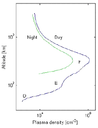 The ionosphere is a complex part of the atmosphere, lying from about 60 km of altitude up to several hundreds of kilometres. The ionising radiations of the sun and energetic particles transported by the solar wind produce concentration of free electrons especially in the 250-400 km high layer known as the F-region. This phenomenon results in changes in the refractive index of the medium. Radio-electric waves over 100 MHz that cross the ionosphere are then refracted and delayed. In the L-band, which corresponds to the GPS frequencies, the delay may reach several tens of meters.
| are the receiver and satellite clocks offsets with respect to the GPS system time, | |
| is the tropospheric delay, | |
| is the ionospheric delay, | |
| are the satellite and receiver hardware delays, expressed in unit of time, | |
| is a random error (or residual). |
![]() estimated
uncertainties are 3 meters for C/A code and 0.3 m for P-code.
estimated
uncertainties are 3 meters for C/A code and 0.3 m for P-code.
Phase observations
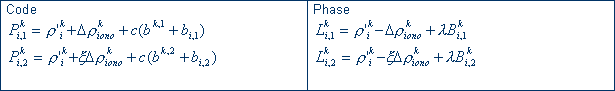
The carrier phase observation after multiplication by the signal wavelength at each frequency is expressed in meter as:
![]()
where
| is the corresponding wavelength and | |
| is the
constant bias (initial carrier phase ambiguity |
Estimated uncertainties of ![]() are very low around 2 mm.
are very low around 2 mm.
Linear combination of code and phase
The linear combination of codes or/and phases is at the basis of any GPS data
processing. For dual-frequency geodetic GPS receivers, a simplified
frequency-dependent notation is adopted ![]() .
.
![]() 1=1575.42 MHz
1=1575.42 MHz
![]() 2=1227.60 MHz
2=1227.60 MHz
where ![]() .
.
The difference of two codes (P2-P1) or phases (L2-L1) quasi-simultaneously acquired almost completely eliminates the geometric terms and associated errors (satellite orbit, clock offsets, troposphere). It is called the "geometry free linear combination" and classically used for ionospheric investigations. (P2-P1) gives the absolute level of ionospheric correction with the code uncertainty while the ambiguities remain on (L2-L1) phase difference.
What are the effects of the ionosphere on the GPS signals?
Effects description
When a radio-signal propagates across the ionosphere, it is both bent and
retarded. The ionospheric path delay results from the integration of the
refractive index which is < 1 and varies as a function of the electron
content N and the signal frequency ![]() .
.
The ionospheric correction of the GPS observations may be related to the Total Electronic Content (TEC) as follows:
![]() where
where ![]() (>0 for code and <0 for phase),
(>0 for code and <0 for phase),
![]() is the line-of-sight or slant Total Electronic Content
in 1016 electrons per square meter (TECU unit), and
is the line-of-sight or slant Total Electronic Content
in 1016 electrons per square meter (TECU unit), and ![]() is the frequency.
is the frequency.
The ionospheric path delay is about 0.162m/TECU at frequency ![]() 1.
1.
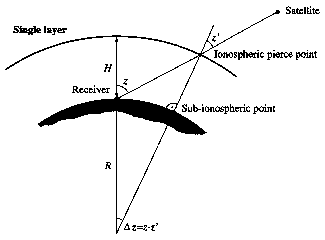 For absolute TEC mapping using the ground-based GPS data, a mapping function
is required to provide the TEC along the vertical. A so-called single-layer
model is used. All free electrons are assumed to be contained in a shell of
infinitesimal thickness at altitude H. The altitude of this idealized layer is
usually set to 400 kilometers approximately corresponding to the altitude of
maximum electron density.
For absolute TEC mapping using the ground-based GPS data, a mapping function
is required to provide the TEC along the vertical. A so-called single-layer
model is used. All free electrons are assumed to be contained in a shell of
infinitesimal thickness at altitude H. The altitude of this idealized layer is
usually set to 400 kilometers approximately corresponding to the altitude of
maximum electron density.
The relation between the vertical VTEC or TEC(0) and the slant TEC(z) if z is the satellite zenith distance at the receiver's location (figure 2) is:
![]() with
with ![]()
z' being the satellite's zenith distance at the point where the single layer
is pierced.
Ionosphere at Yellowknife (Canada- AOA Benchmark receiver)
Quiet magnetic period (July 19th, 2004)

The Geometry free linear combination is applied on both the code observations
(P2-P1) and the phase observations (L2-L1). The latest is biased due to the
ambiguities but the two terms should indicate the same tendency versus time
(about 1 m after 1 hour). In this case, it is clear that the code differences
are much less precised than the phase differences. This is reinforced by the low
elevation of the satellite pass affected by a lower budget link and possibly
some tropospheric residual error (not very likely at high latitudes). It is also
notable that the (L2-L1) is affected by a cycle slip. The time differences of
two consecutives terms plotted as D(L2-L1) constitutes an efficient tool to
isolate the cycle slips.
Magnetic storm (October 29th, 2003)
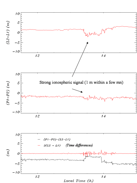
In that case, the ionospheric signals are significant in the order of a one
meter within a few minutes. The level of (P2-P1) noise is reasonable probably
due to a high satellite elevation.
What are the effects of the ionospheric scintillations on the GPS signals?
The most significant effects include the signal power attenuation, the loss of lock (L2 tracking mainly) and the phase fluctuations. Significant impacts are observed on GPS availability, on precise positioning, navigation, determination and transmission of ionospheric dual frequency corrections.
Scintillations at Tromsoe (Norway)
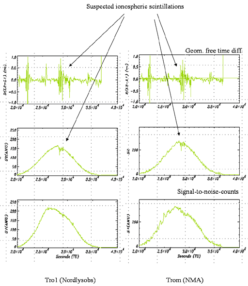
At Tromsoe, two GPS receivers are operating. The figure shows the same
variability of D(L2-L1) -time difference of the phase geometry free - and of the
signal to noise count during the same satellite pass. It should be a phenomena
related to the propagation environment. The two receivers operate with a 1
second repetition rate. The high amplitude of the fluctuations help to suspect
the occurrence of ionospheric scintillations.
Scintillations at Douala (Cameroun)
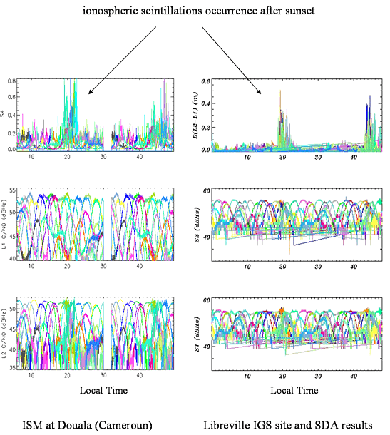
ESA provided calibration data from an ISM (Ionospheric Scintillation Monitor) located at Douala (Cameroun). It is a Novatel material specially adapted to track signal during the signal and calculate their intensity. The classical S4 scintillation index is available every minute and also the C/No. The nearest GPS permanent station is Libreville (gabon) about 400 km South. Even if the repetition rate is 30 s, the empirical scintillation index has been calculated based on high frequency fluctuations of the D(L2-L1) differences. A two days period of quiet magnetic activity has been examined and the plots are given versus local time. It clearly appears that between 19h up to 22h local time, perturbations appear in the two equipments. For Libreville, the scintillation indicator is not yet normalized.
P being the amplitude of the signal, ![]()
Copyright © 2003-2005 |